![]()

ERIMS offers two very powerful and versatile mapping tools as modular add-ons.
STATIC MAPPING enables you to post pre-constructed maps of a facility, turn layers on and off, and perform spatial queries.
DYMANIC
MAPPING, which is an optional module, enables you to build custom maps
from a list of GIS layers and existing GIS maps. It also enables you
to upload GIS layers and manage them within the system.
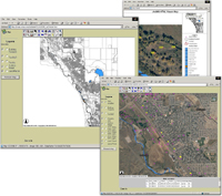 click here for larger img |
ERIMS
uses ESRI ArcIMS to serve GIS maps which provides numerous tools
for visualization and analysis. ERIMS provides tools to select
map items by string queries or spatial queries, and via polygon,
line, area, and buffer zones (without the need to buy a license
of ArcIMS). |
The query results can be passed to various data management tools for evaluation. ERIMS enables you to print, chart, or display the results in tabular or spatial format on a map. The next release of ERIMS will allow you to display geotechnical data in other formats (e.g., as log files, cross-sections, and fence diagrams).
ERIMS
can store GIS data as user-created shape (.shp) files. ERIMS can also
store GIS data through ESRI Spatial Database Engine (SDE) using Microsoft
SQL/Server for management of sample point coverages. SDE is directly
tied to the tools found in the environmental management module of ERIMS.
As you add or update the data for a sample point, such as its coordinates,
point type, or display name, ERIMS mapping system automatically updates
the map at the next user request. As you upload map coverages to a storage
bin, ERIMS provides a list of available coverages for use within the
ArcIMS environment. As you pick the coverages necessary to create a
map, ERIMS mapping system will dynamically build the mapping service
and display the map.
ERIMS security module enables you to manage who has rights to upload map layers. ERIMS mapping system validates the uploaded coverage, creates the new map service, and posts the updated map. Once a map layer has been loaded into ERIMS, rendering properties can be applied to customize the objects in the layer, the control labels, and the symbols.
Tool capabilities include:
![]() List the coverages
List the coverages
![]() Activate particular coverages
for display
Activate particular coverages
for display
![]() Spatially query map elements
Spatially query map elements
![]() Zoom in, out, pan
Zoom in, out, pan
![]() Legend
Legend
![]() Measure distances
Measure distances
![]() Overview map
Overview map
![]() Find/Search
Find/Search
![]() Set units
Set units
![]() Buffer
Buffer
![]() Zoom to active layer
Zoom to active layer
![]() Print parameters
Print parameters
![]() Print with a layout
Print with a layout
![]() Export query results for
analysis
Export query results for
analysis